 fr
 es
 en
Lacs des Bouillouses
Estany de la Bollosa
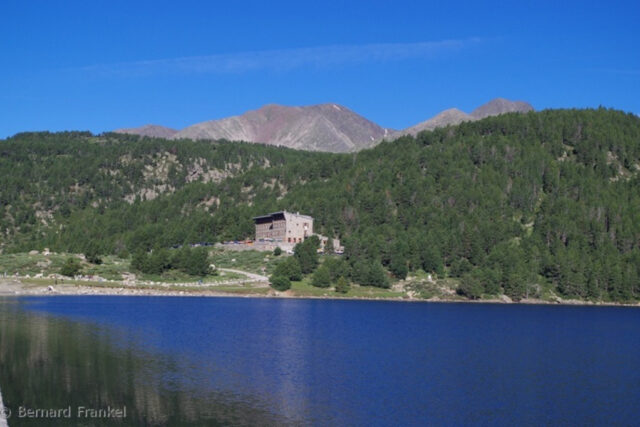
Protected site (1976)At 2,016 metres, at the foot of the Carlit, the Lac des Bouillouses and the surrounding lakes form one of the great high-mountain landscapes of the Catalan Pyrenees: a protected site, accessible by shuttle in summer.
Visit Opening hours, prices, access and events on site ↓Overview
On the high plateau separating the Cerdagne from the Capcir, the Lac des Bouillouses lies at an altitude of 2,016 metres, amid mountain pine forests, peat bogs and granite peaks. Around it, twenty-seven lakes and pools are strung out as far as the Pic Carlit, the highest point in the Pyrénées-Orientales (2,921 m).
The lake is partly man-made. In 1902, the State decided to build a dam there to regulate the Têt and to produce electricity for the Cerdagne railway, the future Train jaune. A 12-kilometre road was opened first, then the masonry dam, 364 metres long, was built between 1904 and 1910, during the summer months only. The lake now covers about 149 hectares, with a maximum depth of 25 metres.
Listed as a protected site in 1976, it attracts many visitors. To protect it, the Département has regulated traffic since the early 2000s: in summer, the road is closed to cars during the day and shuttles run up from the Pla de Barrès car park. According to the Département, this regulation has halved car-related pollution.
The plateau is a refuge for high-mountain fauna and flora: the Pyrenean desman in the pure waters, the chamois, the marmot, the capercaillie and the bearded vulture, and in the peat bogs, cotton grasses and butterwort, a small carnivorous plant.
Key figures
- Lake altitude
- 2,016 m
- Lake area
- about 149 ha
- Maximum depth
- 25 m
- Dam
- 364 m long, built from 1904 to 1910
- Lakes and pools on the plateau
- 27
- Pic Carlit
- 2,921 m
Wildlife, plants and landscapes
A dam for the Train jaune
Decided in 1902 and built only in summer from 1904 to 1910, the dam regulates the Têt and was designed to supply electricity to the Cerdagne line.
The mountain pine
A survivor of the Ice Age, it dominates the high-altitude forests between 1,600 and 2,500 m and can reach 25 metres.
The Pyrenean desman
A small, almost blind mammal, mostly active at night, it is among the rarest species in France and lives in pure waters up to 2,700 m.
Protected peat bogs
Cotton grasses and butterwort, a carnivorous plant, grow in the wetlands that the Département has protected since 2000.
A Spanish pasture
Under the Treaty of the Pyrenees, the Spanish municipality of Llívia owns a grazing area near the lake: French and Spanish herds graze side by side.
The roof of the département
The Pic Carlit (2,921 m), the highest point in the Pyrénées-Orientales, can be climbed from the dam, with a short stretch of easy scrambling.
When to go
The site is best explored from June to September. In 2026, the access road (RD 60) is closed to cars from 7 a.m. to 7 p.m. on certain weekends in June and September, and every day from 4 July to 30 August: a paid shuttle then runs up from the Pla de Barrès car park. Outside these periods, it is possible to drive up to the dam. In winter, the plateau can be explored on snowshoes or by ski touring.
Getting there
From Font-Romeu and Pyrénées 2000, follow the RD 60 to the Pla de Barrès car park (shuttle in summer) or to the dam out of season. You can also go up by the Font-Romeu chairlift, then allow about 35 minutes' walk. Motorhomes are prohibited in the protected site, and overnight parking is prohibited in the dam car parks in summer.
Not to be missed
- The circuit of the Carlit lakes: 9 lakes in 2 h 20 or 12 lakes in 3 h 30
- The ascent of the Pic Carlit, roof of the Pyrénées-Orientales
- The Étangs des Esquits
- The small stone refuge of la Pradella
- The century-old dam, at the foot of the lake
Plan your visit
Sources
- Département des Pyrénées-Orientales : Les Bouillouses, saison 2026
- Département des Pyrénées-Orientales : brochure des Bouillouses
- Département des Pyrénées-Orientales : réglementation du site
- Département des Pyrénées-Orientales : les 20 ans des Bouillouses
- SHEM : aménagements hydroélectriques de la vallée de la Têt
- Wikidata Q1609139
Text written by Éden Catalán from these sources. Spotted a mistake? Write to us.